
Topographical Maps
|
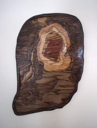
This piece demonstrates how we portray land at Lakes of Wood, as well as lakes. This is Wee Sandy Lake in Ontario, Canada. At the north end of the lake, you can see where McHugh Creek enters Wee Sandy, and along the west side is where McHugh Creek exits by means of a 25 foot waterfall. It then winds it's way through a steep, narrow valley on it's way to the wild rice beds upstream of Dinorwic Lake. The layers of dark, surrounding wood in this piece shows the topography of the land around Wee Sandy Lake, all the way down to the Ontario town of Dinorwic. A few of the buildings in Dinorwic are marked by the small squares in the southwest corner of the wall hanging. The hills, valleys, fields and rock outcroppings
are all portrayed in various levels of wood, bringing the land to three dimensional life! 
|